The Castle Before Stone - Understanding the Site Bishop Alexander Inherited
A Short Note on the Next Blogs
This weekly blog begins a short sequence exploring the early life of the current castle site — why it is located where it is, and what came before. I return to the site in mid‑April after the Easter break to examine building progress.
For now, I will hold on to where the “second” Newark Castle is so that I can take better photographs than I currently have.
A Working Castle Before the Stone Architecture Arrived
After the Battle of Hastings in 1066, the ambitious Norman elite asserted their authority through a rapid building phase. A timber castle was established on the site now occupied by the stone castle.
Archaeological evidence points to an earth‑and‑timber construction — the kind that could be raised quickly to secure a strategic position above the Trent and close to the line of the Fosse Way.
The Domesday Book dating evidence
The Domesday Book (1086) becomes decisive for dating the first Newark Castle. It records Newark in detail — households, ploughlands, a mill, a fishery, and ten churches — but makes no reference to a castle.
That silence is decisive: the first fortification must have been built after 1086 (or Domesday overlooked it — possible, but highly improbable). This provides a single, robust chronological anchor for Newark’s earliest castle phase.
Understanding this first building phase matters because it reveals the landscape Alexander inherited and drives the logic that shaped his later decisions. The early site was already functioning as an episcopal centre before Bishop Alexander set the castle in stone./

The Newark entry from the Domesday Book published on the Open Domesday website.
The Original Newark Castle
The original timber castle had administrative purposes rather than military. It oversaw river movement, regulated the crossing, and anchored episcopal influence in a region where land, water, and jurisdiction met.
The landscape dictated the form: a defensible platform above the river, a controlled approach from the town, and a relationship with the water that was as much about revenue and regulation as defence.
Earth, Timber, and Function
Archaeology points to a motte‑and‑bailey arrangement, with timber structures defining the precinct. The motte likely took advantage of natural geological elevation — no artificial mound survives above ground. It would probably have been topped with a timber tower or keep.
The bailey formed an enclosed courtyard containing the functional buildings of an episcopal estate: a hall, storage structures, a chapel space, and the infrastructure needed to manage people and goods.
There was probably very little ornamentation — nothing designed to impress — just a working site shaped by need and by the authority of the bishopric.
This earlier phase frames Alexander’s later choices. He did not build on a blank canvas, but inherited a landscape already organised around episcopal power, tied to the river economy, and functioning as a node in the diocese’s administrative network. His stone rebuilding made permanent what had previously been provisional.
The river is tidal up to three miles below Newark (at today’s Cromwell Lock), which strengthens the argument that the castle’s purpose was not to repel invaders but to regulate traffic and generate income.
The castle would have been a revenue machine: tolls on goods, fees for crossing, and absolute control over movement. Nearly a thousand years later, there are still only ten Trent crossings between Nottingham and the Humber — and only three of those lie between Newark and the Humber.

An extract from the UK Geological Survey for Newark area, showing the slightly elevated area of the Castle - a natural platform for building a Castle Keep/Motte.
The Triangle of Episcopal Power
Newark’s early importance becomes clearer when placed within Alexander’s wider building programme. His work created a deliberate triangle, each within a practical day’s ride of the others:
- Lincoln as the spiritual and administrative centre
- Newark as the river‑crossing strongpoint
- Sleaford as the inland counterpart controlling movement across the fen edge
At the southern edge of the Lincoln diocese stood Alexander’s other castle at Banbury, extending his administrative reach.
These were not isolated projects but coordinated expressions of episcopal authority across the landscape. Newark’s early timber phase sits squarely within that pattern — a functional node awaiting later architectural consolidation.
Alexander’s building programme formed only part of the wider network of episcopal manors, residences, and court sites that he used as he travelled through his vast diocese. Newark, Sleaford, and Banbury were simply the places he chose to consolidate in stone.
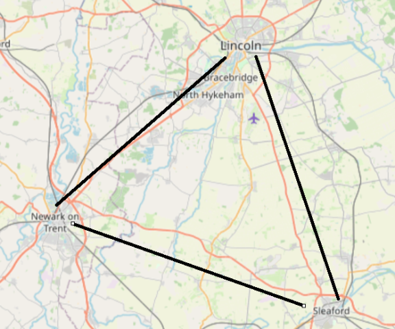
The triangle of the three towns (Map data © OpenStreetMap contributors, ODbL.)
Setting the Stage for Stone
Seeing Newark Castle in this earlier, pre‑stone phase helps us understand the decisions that follow. It reveals a site already alive with purpose, shaped by the needs of governance and revenue generation, and positioned within a wider network of episcopal power. The stone castle that emerges in Blog 5 is the next step in that story — not a beginning, but a consolidation, authorised by a charter issued by King Henry I in 1135.